
Uncategorized


Temporary Road Closure
A temporary road closure has been put in place to allow Fibrus Networks Limited to carry out utility works which are expected to commence 18th June 2025 and anticipated to take 3 days to complete.
Please see below details of the extents of the restriction(s) and any alternative route(s) which may be in place, the relevant legal notice can be viewed at https://api-gb.one.network/downloads/tm/4587/reactivation-notice-w-f_143653656_3920658_ffa773d8fe.pdf and a location plan clearly showing these extents can be found on one.network via link https://one.network/?tm=143653656
Location: U5095 Soutergate, from a point approx. 300m northeast of its junction with the A595, extending in a predominately easterly direction for a distance of approx. 400m.
Alternative Route: A suitable alternative route will be signed and made available via the unrestricted section of the U5095, C5016 and A595. A way for pedestrians and dismounted cyclists will be maintained at all times.
N.B Passage for Emergency Vehicles will be maintained where required for the duration of this restriction.
Should you have any queries in relation to this temporary Order please contact the Highways Hotline by calling 0300 373 3306 or via the Westmorland & Furness Council website, quoting the reference TTROW/15189

KIRKBY IN FURNESS SPEED DATA MONITORING
Speed data monitoring has been conducted in August and November 2024 (in locations 1, 2, 3 and 4 marked on the map) following concerns raised by Kirkby Ireleth Parish Council regarding speeding vehicles travelling through the village on the A595. Speed data collected in December 2022 has also been included in this report (location 5) as concerns have also been raised regarding vehicle speeds at Beckside. The posted speed limit (PSL) is 40mph in locations 1 and 2, 30mph in locations 3 and 4 and 20mph in location 5.
Westmorland and Furness Highways Officers conducted a site visit to determine the most suitable locations (based on extensive experience gathering high quality traffic data) to situate temporary data collection tubes which are used to collect the data over a seven-day period. Alongside the requirement for speed data tubes to be secured to street furniture, consideration must be made to ensure tubes are not situated in positions may be affected by close proximity of junctions, accesses or parked vehicles.
The ACPO limit refers to the Association of Chief Police Officers (ACPO) enforcement threshold, which was a guideline used by police forces in the UK to determine when to take action against speeding drivers. Although ACPO was replaced by the National Police Chiefs’ Council (NPCC), the general enforcement thresholds have remained similar. The guideline suggests that enforcement action (such as fines or points on a licence) typically begins at:
- Speed Limit + 10% + 2 mph
- 20 mph zone → Action at 24 mph
- 30 mph zone → Action at 35 mph
- 40 mph zone → Action at 46 mph
- 50 mph zone → Action at 57 mph
LOCATIONS
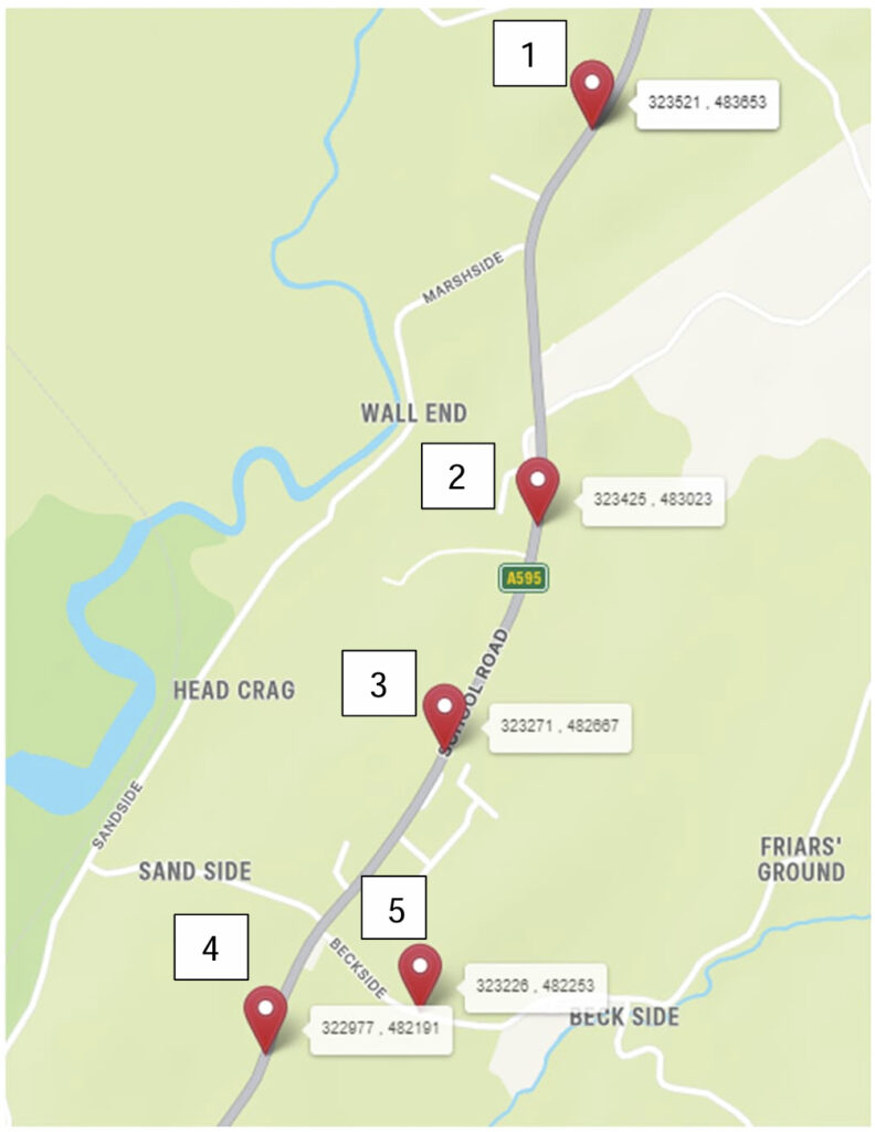
LOCATION 1
The two-way mean speed was recorded as 44.3mph. In a south westerly direction this was recorded as 42.3mph and in a northwesterly direction it was recorded as 46.2mph. The monitoring indicated that 35.1% of vehicles were travelling at speeds greater the ACPO Limit.
LOCATION 2
The two-way mean speed was recorded as 42.2mph. In a southerly direction this was recorded as 44.1mph and in a northerly direction it was recorded as 40.2mph. The monitoring indicated that 23.5% of vehicles were travelling at speeds greater the ACPO limit.
LOCATION 3
The two-way mean speed was recorded as 30.7mph. In a southerly direction this was recorded as 28.9mph and in a northerly direction it was recorded as 32.6mph. The monitoring indicated that 18.5% of vehicles were travelling at speeds greater the ACPO limit.
LOCATION 4
The two-way mean speed was recorded as 35.3mph. In a southerly direction this was recorded as 35.1mph and in a northerly direction it was recorded as 35.4mph. The monitoring indicated that 47.6% of vehicles were travelling at speeds greater the ACPO limit.
LOCATION 5
The two-way mean speed was recorded as 23.1mph. In a southeasterly direction this was recorded as 24.0mph and in a northwesterly direction it was recorded as 22.3mph. The monitoring indicated that 42.7% of vehicles were travelling at speeds greater the ACPO limit.
CONCLUSION
The data confirms that speeding remains a serious concern, with a significant proportion of vehicles exceeding enforcement thresholds, particularly in 30 mph and 20 mph zones. While many of these offenders are likely non-local drivers passing through, a proportion will be residents. This highlights the need for increased awareness and action to improve road safety in our village.
The Parish Council will use this data when lobbying Highways for further mitigation measures. While improved road markings are already planned, we will be pushing for better traffic calming solutions.
Your support in raising awareness and adhering to speed limits will help make Kirkby-in-Furness a safer place for everyone.
FULL REPORT HERE


Parish Councillor Vacancy Filled
The Parish Council vacancy has now been filled. Welcome to Cllr Vance Sarson who was co-opted in at the meeting on 20th February 2025.
About the role:
FREE FESTIVE PARKING
| NEWS RELEASE: Enjoy FREE festive parking across Westmorland and Furness On Saturdays in Barrow and Eden, and Sundays in South Lakeland, free parking will be offered at participating council-owned car parks on the run up to Christmas |
| Shoppers can enjoy FREE weekend parking at over 40 council-owned car parks throughout December. With the holiday season upon us, Westmorland and Furness Council has launched a free parking initiative designed to make it easier to support local businesses and enjoy the festivities right across the area without worrying about parking costs. On Saturdays in Barrow and Eden, and Sundays in South Lakeland, free parking will be offered at participating council-owned car parks on the run up to Christmas. The council-funded scheme aligns with the ongoing commitment to supporting communities, strengthening the local economy, and making the area an attractive destination for residents and visitors. Cllr Peter Thornton, Westmorland and Furness Council Cabinet Member for Highways and ICT said: “As we approach the festive season, we understand how important it is for residents and visitors to have easy access to our towns and villages. “Local businesses are at the heart of our communities, and this time of year is crucial for their success. By offering free weekend parking at council-owned car parks throughout December, we’re making it simpler for people to shop locally, enjoy festive events, and support the brilliant range of businesses we have across Westmorland and Furness. “We’re proud to provide this opportunity and encourage everyone to take advantage of it by exploring all that our towns and villages have to offer during this special time of year.” Before parking up, people are encouraged to check the following list of participating car parks and the select dates free parking will be offered. Saturday 7, 14 and 21 December in Eden Bluebell Lane Drover’s Lane Sandgate Princes Street Mansion House Town Hall Saturday 7, 14 and 21 December in Barrow Market Street Hall Street. Sunday 8, 15 and 22 December in South Lakeland Quarry Mount, Bowness Glebe Road, Bowness Braithwaite Fold, Bowness Ferry Nab, Bowness Rayrigg Road, Bowness Rayrigg Meadow, Windermere Broad Street, Windermere Low Fold, Ambleside Miller Bridge, Ambleside King Street, Ambleside Lake Road, Ambleside Rydal Road, Ambleside Red Bank Road, Grasmere Kendal Parish Church, Kendal Peppercorn Lane, Kendal Highgate Bowman, Kendal Dowker Lane, Kendal Booths, Kendal Library Road, Kendal South Lakeland House, Kendal Blackhall Road, Kendal Sandes Avenue, Kendal New Road Number 1, Kirkby Lonsdale New Road Number 2, Kirkby Lonsdale Market Square, Kirkby Lonsdale Windermere Road, Grange-Over-Sands Main Street, Grange-Over-Sands Hampsfell Road, Grange-Over-Sands Kents Bank Road, Grange-Over-Sands Berners Close, Grange-Over-Sands Brewery Street, Ulverston Buxton Place, Ulverston The Gil, Ulverston Daltongate, Ulverston Stockbridge Lane, Ulverston Thearte Street, Ulverston Beetham Road, Milnthrope Park Road, Milnthrope. The list of participating car parks and their locations can also be found on the ‘News’ section of www.westmorlandandfurness.gov.uk. |
Are You Winter Ready?
The Westmorland and Furness Council has launched a “Winter Ready” campaign, preparing frontline services for colder months. It provides advice and support on issues like highways and gritting, flooding, staying warm, cost-of-living help, and mental health resources. Residents are encouraged to prepare for winter by accessing these services and following the council’s updates for tips on staying safe and well during the season. The campaign aims to ensure both the council and the community are ready for winter challenges.
More details can be found here.
